
Portal:Cyprus
The Cyprus Portal

Cyprus (/ˈsaɪprəs/ ⓘ), officially the Republic of Cyprus, is an island country in the eastern Mediterranean Sea, north of the Sinai Peninsula, south of the Anatolian Peninsula, and west of the Levant. It is geographically a part of West Asia, but its cultural ties and geopolitics are overwhelmingly Southeast European. Cyprus is the third-largest and third-most populous island in the Mediterranean. It is east of Greece, north of Egypt, south of Turkey, and west of Lebanon and Syria. Its capital and largest city is Nicosia. The northeast portion of the island is de facto governed by the self-declared Turkish Republic of Northern Cyprus.
Cyprus is home to some of the oldest water wells in the world. Cyprus was settled by Mycenaean Greeks in two waves in the 2nd millennium BC. As a strategic location in the Eastern Mediterranean, it was subsequently occupied by several major powers, including the empires of the Assyrians, Egyptians and Persians, from whom the island was seized in 333 BC by Alexander the Great. Subsequent rule by Ptolemaic Egypt, the Classical and Eastern Roman Empire, Arab caliphates for a short period, the French Lusignan dynasty and the Venetians was followed by over three centuries of Ottoman rule between 1571 and 1878 (de jure until 1914).
Cyprus was placed under the United Kingdom's administration based on the Cyprus Convention in 1878 and was formally annexed by the UK in 1914. The future of the island became a matter of disagreement between the two prominent ethnic communities, Greek Cypriots, who made up 77% of the population in 1960, and Turkish Cypriots, who made up 18% of the population. From the 19th century onwards, the Greek Cypriot population pursued enosis, union with Greece, which became a Greek national policy in the 1950s. The Turkish Cypriot population initially advocated the continuation of the British rule, then demanded the annexation of the island to Turkey, and in the 1950s, together with Turkey, established a policy of taksim, the partition of Cyprus and the creation of a Turkish polity in the north. (Full article...)
Selected article -

Troodos (sometimes spelled Troödos; Greek: Τρόοδος [ˈtɾo.oðos]; Turkish: Trodos Dağları ['tɾo.dos]) is the largest mountain range in Cyprus, located in roughly the center of the island. Its highest peak is Mount Olympus (Greek: Όλυμπος), also known as Chionistra (Greek: Χιονίστρα), at 1,952 metres (6,404 ft), which hosts the Sun Valley and North Face ski areas with their five ski lifts.
The Troodos mountain range stretches across most of the western side of Cyprus. There are many mountain resorts, Byzantine monasteries, and churches on mountain peaks, and nestling in its valleys and mountains are villages clinging to terraced hills. The area has been known since antiquity for its mines, which for centuries supplied copper to the entire Mediterranean. In the Byzantine period it became a centre of Byzantine art, as churches and monasteries were built in the mountains, away from the threatened coastline. The mountains are also home to RAF Troodos, a listening post for the NSA and GCHQ. (Full article...)Cyprus news
General images
-

-
 Hoisting the British flag at Nicosia (from Cyprus)
 -
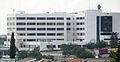 Limassol General Hospital (from Cyprus)
 -
 Cypriot cult image. 'Red Polished Ware', 2100–2000 BC. Museum zu Allerheiligen (from History of Cyprus)
 -
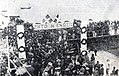
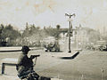
 Turkish rally in Nicosia in January 1958 (from Cyprus problem)
 -
 The Armenian Alphabet at the Melkonian Educational Institute. Armenian is recognised as a minority language in Cyprus. (from Cyprus)
 -
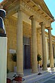
 Supreme Court of Justice (from Cyprus)
 -
-
 Under the control of the Republic of Cyprus(from Cyprus problem)
 -
 "TAKSİM" (division) graffiti on a wall in Nicosia in the late 1950s (from Cyprus problem)
 -
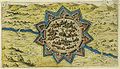
![Image 11Cypri insvla nova descript 1573, Ioannes á Deutecum f[ecit]. Map of Cyprus newly drawn by Johannes van Deutecom, 1573. (from Cyprus)](//upload.wikimedia.org/wikipedia/commons/thumb/b/b7/Atlas_Ortelius_KB_PPN369376781-073av-073br.jpg/120px-Atlas_Ortelius_KB_PPN369376781-073av-073br.jpg) Cypri insvla nova descript 1573, Ioannes á Deutecum f[ecit]. Map of Cyprus newly drawn by Johannes van Deutecom, 1573. (from Cyprus)
Cypri insvla nova descript 1573, Ioannes á Deutecum f[ecit]. Map of Cyprus newly drawn by Johannes van Deutecom, 1573. (from Cyprus) -
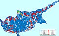 Ethnic map of Cyprus according to the 1960 census (from Cyprus)
 -
 Cyprus is part of a monetary union, the eurozone (dark blue) and of the EU single market. (from Cyprus)
 -
-
 Ioannis Kigalas (c. 1622–1687) was a Nicosia born Greek Cypriot scholar and professor of Philosophy who was largely active in the 17th century. (from Cyprus)
 -
 Kyrenia Castle was originally built by the Byzantines and enlarged by the Venetians. (from Cyprus)
 -
 The entrance of the historic Pancyprian Gymnasium (from Cyprus)
 -
 Population growth, 1961–2003 (numbers for the entire island, excluding Turkish settlers residing in Northern Cyprus) (from Cyprus)
 -
 Base ring vessel of Late Bronze Age (from History of Cyprus)
 -

-
 Street close to the Nicosia border (from Cyprus problem)
 -
 The Walls of Nicosia were built by the Venetians to defend the city in case of an Ottoman attack. (from Cyprus)
 -
 Statue of Liberty symbolising the independence of Cyprus. (from History of Cyprus)
 -
 Atatürk Square, North Nicosia in 2006 (from Cyprus problem)
 -
Street in the divided capital of Nicosia (from Cyprus)
-
 The "Green Line" in Nicosia, Cyprus. (from Cyprus problem)
 -
 Varosha (Maraş), a suburb of Famagusta, was abandoned when its inhabitants fled in 1974 and remains under Turkish military control. (from Cyprus)
 -
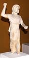 Zeus Keraunios, 500-480 BC, Nicosia museum (from History of Cyprus)
 -
 A Sentinel-2 image of Cyprus taken in 2022 (from Cyprus)
 -

-
 The Troodos Mountains experience heavy snowfall in winter. (from Cyprus)
 -
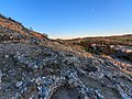
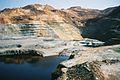 A copper mine in Cyprus. In antiquity, Cyprus was a major source of copper. (from Cyprus)
 -
 Cathedral of Saint Nicholas, consecrated in 1328, the largest medieval building in Famagusta, where the Kings of Cyprus were crowned also as Kings of Jerusalem. In 1571 having fallen to the Ottoman Empire it became the Mosque of Mağusa, and remains a mosque today (from History of Cyprus)
 -
 Faneromeni School is the oldest all-girl primary school in Cyprus. (from Cyprus)
 -
 Ayia Paraskevi Byzantine church in Yeroskipou, Cyprus (from History of Cyprus)
 -

-
 Archaeological site of Khirokitia with early remains of human habitation during the Aceramic Neolithic period (reconstruction) (from Cyprus)
 -

-
 Kouris Dam overflow in April 2012 (from Cyprus)
 -
Zeus Keraunios, 500–480 BC, Nicosia museum (from Cyprus)
-
 A British soldier facing a crowd of Greek Cypriot demonstrators in Nicosia (1956) (from Cyprus)
 -
 Accession of Cyprus to the European Union in 2004(from Cyprus problem)
 -
 Sea caves at Cape Greco (from Cyprus)
 -
 Büyük Han, a caravanserai in Nicosia, is an example of the surviving Ottoman architecture in Cyprus. (from Cyprus)
 -

-
 Red-polished ceramics from Enkomi, 1900–1725 BC. St. Barnabas Archaeological Museum, Salamis, Cyprus (from History of Cyprus)
 -
 Central Bank of Cyprus (from Cyprus)
 -

-
 Foreign Ministers of the European Union countries in Limassol during Cyprus Presidency of the EU in 2012 (from Cyprus)
 -
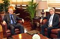 Greek Cypriot negotiator Andreas Mavroyiannis and the Turkish Undersecretary of Foreign Affairs Feridun Sinirlioğlu, in Ankara, within the scope of the 2014 Cyprus talks (from Cyprus problem)
 -
 2010 population by age and gender (from Cyprus)
 -
 Cyprus in 1482 (from History of Cyprus)
 -
 Dhekelia Power Station (from Cyprus)
 -

-
 Welcoming ceremony of the former Russian president Dmitry Medvedev by the soldiers of the Cypriot National Guard (from Cyprus)
 -

-
 Opening of Ledra Street in April 2008 (from Cyprus problem)
 -

-
 UN tower in the buffer zone (from Cyprus)
 -
 Proposed flag of the United Republic of Cyprus (from Cyprus problem)
 -
A Greek Cypriot demonstration in the 1930s in favour of Enosis (union) with Greece (from Cyprus problem)
-
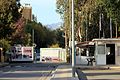
 The north–south checkpoint has been open since 2003 (from Cyprus problem)
 -
 Ottoman admiral, geographer and cartographer Piri Reis' historical map of Cyprus (from Cyprus problem)
 -
 Khirokitia archeological site. (from History of Cyprus)
 -
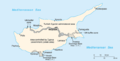 A map showing the division of Cyprus (from Cyprus)


![Image 11Cypri insvla nova descript 1573, Ioannes á Deutecum f[ecit]. Map of Cyprus newly drawn by Johannes van Deutecom, 1573. (from Cyprus)](/wiki/File:Atlas_Ortelius_KB_PPN369376781-073av-073br.jpg)


_Cyprus.jpg)


_-_BEIC_6353768.jpg)


.svg)


.jpg)


The time allocated for running scripts has expired. The time allocated for running scripts has expired.
Religions in Cyprus The time allocated for running scripts has expired.
Countries with related heritage The time allocated for running scripts has expired.
Nearby countries The time allocated for running scripts has expired.
The time allocated for running scripts has expired. The time allocated for running scripts has expired.The time allocated for running scripts has expired.
The time allocated for running scripts has expired.

The time allocated for running scripts has expired.
The time allocated for running scripts has expired.
- Improve the project; WikiProject Cyprus
The time allocated for running scripts has expired.
The time allocated for running scripts has expired.
The following Wikimedia Foundation sister projects provide more on this subject:
-
 Commons
Free media repository -
 Wikibooks
Free textbooks and manuals -
 Wikidata
Free knowledge base -
 Wikinews
Free-content news -
 Wikiquote
Collection of quotations -
 Wikisource
Free-content library -
 Wikiversity
Free learning tools -
 Wikivoyage
Free travel guide -
 Wiktionary
Dictionary and thesaurus


